The following was written for the AEthelmearc Gazette
Ask Another Laurel - It's Flat, Like a Pizza
by Caleb Reynolds
Did people in the middle ages really think that the Earth was flat?
I'm certain that some people did, just like some people today hold that supine view. But most people, particularly the people who made the maps, sailed the ships, and surveyed the land knew that the Earth was a sphere. But, why do we keep reading that the medieval world thought that the Earth was flat and only "The Great Navigator" Christopher Columbus (Cristoffa Corombo in his native tongue) knew that it was actually round and he spent years trying to convince the Crown of Spain that he was 100% correct and everyone else was 100% wrong?
To answer that question we first have to go back into time. All the way back to 240BCE to the Greek City-State of Alexandria, where the chief librarian and mathematician, Eratosthenes of Cyrene, heard about a particular well in Syene, along the Nile. On the summer solstice, the sun shone directly down this well, at noon, illuminating the water but not the sides of the well. Eratosthenes knew from observation that this phenomenon did not occur in Alexandria and, like all really smart people, wanted to figure out why. Eratosthenes made the connection that since the Earth was a sphere (The Greeks knew about this fact since the 4th Century BCE), he would be able to use simple trigonometry to figure out the actual size of the Earth. Eratosthenes hired three different people to accurately measure not just the distance between Alexandria and Syene, but the distance between the well at Syene and a stick Eratosthenes had positioned vertically in Alexandria.
The average of the three measurements was 5,000 stadia (a Greek stadion was about 185 meters but an Egyptian stadion was about 157.5 meters. Alexandria might have been a Greek occupation, but it was an Egyptian city) and the angle of the shadow cast by the stick was 7.2 degrees. Simple trigonometry tells us that the circumference of the Earth, using Egyptian stadion, would be 250,000 stadia or 39,425km: about 2% off of the modern measurement of 40,008km. (If you use the Greek measurement you end up with 46,250km, about 16% off. [1] Ancient Indian, Persian, Arabic, and African astronomers and mathematicians confirmed the circumference of the Earth, by a variety of methods, and this measurement was used by Medieval European scholars.
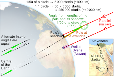 |
| Figure 1 |
So, where did this idea that everyone thought that the Earth was flat except for Columbus come from? Well, most of it comes from Washington Irving’s "A History of the Life and Voyages of Christopher Columbus" (1828), an anti-Catholic screed masquerading as a history book. Irving, who is well known for his other history books, "The Legend of Sleepy Hollow" and "Rip van Winkle", wrote of the narrow mindedness of the Catholic Church, clinging to biblical texts that the Earth was flat; stonewalling the genius, secular thinker Columbus, who I have to add, was also a Catholic. Historian Darin Hayton puts it succinctly and diplomatically, "Whatever liberties Irving took in crafting his biography, he did not lose sight of historical truths. Instead, and perhaps more disturbingly, he enlisted those truths in the service of truthiness. In Irving’s version, Columbus had struggled against “errors and prejudices, the mingled ignorance and erudition, and the pedantic bigotry” of the Spanish Church that refused to listen to reason and evidence. His biography was less about Columbus and more about the timeless struggle between on the one hand rationality, science, individuality, and anti-aristocratic modernity and, on the other hand, a retrograde, oppressive, medieval Church. It was the story’s truthiness that appealed to other 19th-century authors. ... By the latter 19th-century, the supposed truth of the Columbus story had completely replaced the historical truths. In works like John Draper’s "History of the Conflict between Religion and Science" (1874) we read nothing of the reasoned objections raised by the Council at Salamanca or of Columbus’s errors."
Like all conspiracy theories, it begins with a grain of truth as to why Columbus wasn't instantly given what he wanted and why it took 7 years before he was given the ships and the funds to sail off into literally uncharted waters. The actual details are quite interesting and certainly nothing like what I was taught in school, but there are several reasons why it took so long for Columbus to get a fleet.
The first being Columbus had no experience as a ship captain, pilot, or navigator. He did sail a lot, as he was a trading agent for several wealthy families of Genoa. But, and this is important, Columbus was a passenger on all of his trips, not a sailor. While Columbus wrote that he went to sea at the young age of 14, there is no evidence that meant anything more than moving with his family from Genoa to Savona. Columbus would have been working an uphill battle to be taken seriously: He was proposing a radical trade route, which he would lead, while at the same time having nothing on his CV that would make anyone want to take the risk. Those of you who know me, know that I've been working in IT for almost 30 years. If I were to interview someone for a data center operator and they tell me that they would be perfect for the job because they spent a few years driving delivery trucks and they've watched "Sneakers" 100 times, I would ask them to leave.
In fact, comparisons of the pilot logs recorded by Columbus (on the Santa Maria) with the logs of Martín Alonso Pinzón (Captain of La Pinta) and his brother Vicente Yanez Pinzón (Captain of the Santa Clara, which was nicknamed La Niña) do show that the professional sailors were meticulous in their logs and their measurements of latitude and speed. Columbus, on the other hand, used a technique called "dead reckoning" and was very sloppy in his log recordings. Unfortunately, details on the three Captains' work is difficult to find outside of academic pay-walls. The few bits of technical information I did manage to find point to Columbus' inexperience with taking readings and doing the correct math. The Pinzón brothers were very good at their jobs [2] but there are questions about what length league Columbus used and there are serious questions about if he logged fake celestial observations.
The following is from the late Keith Pickering's "Columbus Landfall" website, in which he goes into some detail about celestial navigation: "The quadrant readings Columbus obtained on his first voyage are horrible by any standard. Some have suggested that Columbus mistook another star for Polaris, but that seems ridiculous: Columbus used the stars of Ursa Minor to tell time at night, so he was very familiar with that constellation. In 1983, James E. Kelley, Jr. provided the solution to the mystery: as mentioned above, many quadrants in maritime museums have tangent scales. If Columbus misread the scale, he might have recorded the tangent of his latitude (without the decimal point) instead of his actual latitude. If that were the case, Columbus's measurements would only be wrong by a couple of degrees or so, which is not bad considering the technology. In any case, it is clear that at this point in his career Columbus was not familiar enough with celestial techniques and tools to use them successfully. So it is not surprising that on his second voyage, there is no record that Columbus attempted to use celestial navigation (except for the fraudulent eclipse longitudes). Instead, he stuck to the tried and true dead reckoning practice of "rhumbline sailing", keeping a constant west-by-south course the whole way from Gomera to Dominica in the West Indies."
Columbus would have had to prove himself to competent people, not just royalty who would just give him money based solely on fancy words. If he could not show to professionals that he, someone with no experience sailing a ship, did know how to use the tools of navigation or properly do the math to calculate a ship's position, then he would have been shown the door, regardless of how charismatic he might have been.
The second point being timing. In 1486 Columbus used his trading contacts to get an audience with the joint monarchs of the newly unified Spain. They referred Columbus to a maritime commission who eventually rejected his plan, but Ferdinand and Isabella did hire Columbus as "an agent of the court" with a salary of around 1,000 maravedis per month, or about $3,000 in today's money (based on the work of William Thomas Walsh), good money if you can get it. Spain might have wanted to keep Columbus happy, and in Spain, even if they didn't think he could do what he claimed. We should note that Spain was involved in a war with the Moors in southern Spain and couldn't afford the expense of sending ships and sailors off on what might have been a wild goose chase. In 1488, Columbus went to Lisbon to see if the Portuguese would back his plan, but, Bartholomew Dias had just returned from his successful trip around of the Cape of Good Hope, opening up a trade route to India that bypassed the Middle East. King John wasn't interested in sailing West to India when he was gearing up to set up colonies along Africa that would act as way points for his ships sailing around that continent.
Columbus sent his brother Bartholomew to the Court of Henry VII in hopes that the English would finance the voyage. Henry didn't, and Bartholomew left England for the sunny climate of the court of France's Charles VIII, who didn't care about the plan either, but did convince Bartholomew to stay in France as a royal map maker.
In 1490 Columbus made another appeal to Ferdinand and Isabella and the royal 8-ball said "Try again later." In 1491 he was summoned to the Spanish Court to pitch his proposal to the Dragons. Which leads us to point number 3.
The third point was what Columbus was asking for. Ten million maravedís to outfit a huge fleet of ships and sailors that would have had no oversight. Formal titles for himself and his family. The hereditary titles of Viceroy and Governor over all lands he discovered as well as any lands discovered after his voyage. The perpetual office of Spain's Admiral of the Ocean, which would be passed on to his descendants forever. And 1/10th of all of the gold, silver, pearls, gems, spices, silks, and all other goods produced in all of the lands discovered on this journey to be awarded to him and his descendants forever. Not brought back to Spain, but 1/10th of everything produced in all of the lands discovered. It is worth noting that Columbus was looking for a short cut to Japan and China, so any additions to the European maps would be controlled by Columbus and his family in perpetuity. The Crown sent his offer to a financial committee.
The fourth and final point has to do with the nature of the proposition. Columbus wasn't promoting the idea that the Earth was round; he was promoting the idea that the Earth was small. We must go back into time, again, to find out why. In the 2nd Century BCE a Greek astronomer named Posidonius of Rhodes made observations of the star Canopus. He recorded that when the star was visible at the horizon at Rhodes, it was 7.5 degrees above the horizon at Alexandria. Posidonius used a distance between the two cities as 5,000 stadia which would give a circumference of 240,000 stadia, which was close to Eratosthenes' 250,000 stadia. Unfortunately, this is wrong. The distance between Alexandria and Rhodes is 3,750 stadia and Canopus reaches a height, visible at Alexandria, of only 5.25 degrees.
Claudius Ptolemy, writing in his "Guide to Geography" used Posidonius' calculations instead of Eratosthenes', and he did correct the error in the distance between the two cities. Unfortunately, he used the inaccurate 7.5 degree figure obtaining a value of 180,000 stadia, or around 28,386 km: 14% smaller than what Eratosthenes calculated. This miscalculation was known about almost immediately; Cleomedes wrote about the error in the 1st Century AD, and other mathematicians also noted Ptolemy's math error among other errors (like the Indian Ocean was a large, inland sea and not an ocean). Ptolemy was translated into Latin and other languages in the 10th and 11th centuries and printed in 1475 with movable type: it was very popular and wildly read despite its errors.
We don't know if Columbus owned his own copy of "Guide to Geography", but we know that three people who influenced Columbus did. The first was Pierre d'Ailly, who wrote "Ymago Mundi" in 1410. We know that Columbus did own a copy of this book. In fact, his copy with his hand written notes still survives. d'Ailly wrote that the Atlantic and Pacific oceans were the same ocean, since Ptolemy didn't write about any antipodes, or dry land, in the same latitude as Europe and Asia. Ptolemy also influenced a German map maker named Martin Behaim who also made globes. Behaim was a resident of the Portuguese Court at the time Columbus visited, and Columbus brought one of Behaim's very inaccurate globes with him on the Santa Maria.
Finally, one of Columbus's teachers was Paolo dal Pozzo Toscanelli, who was a brilliant architect and astronomer. He was also a less than brilliant map maker. He had taken Ptolemy's figures and made his own calculation on the size of the Earth and ended up with a number smaller than Ptolemy; some 25% smaller than what we know today. Toscanelli was the one to come up with the plan to sail West until you hit China, which according to his calculations, should only take three weeks if one leaves from Lisbon. Toscanelli had written of his plan to Afonso V of Portugal and had given a copy of the letter, along with one of his maps, to Columbus. [3]
 |
| Figure 2 |
So. We have Columbus, who had no experience in navigating, promoting a crackpot theory of how the world was smaller than what was observed, asking for an extraordinary amount of money and titles to sail off to parts unknown at a time when Spain was in the middle of a war and Portugal was making plans to sail around Africa. I can see why Irving made up the story of how they thought the Earth was flat. It was clearly an easier argument to make. Wrong, but easier to write about.
In January 1492, Spain defeated the Moors in Granada and the Crown once again considered Columbus's plan. Luis de Santangel, financial advisor to the crown, managed to convince Isabella to change her mind about the venture. He argued that the plan “offered so little risk yet could prove of so great service to God and the exaltation of His Church, not to speak of the very great increase and glory of her realms and kingdoms”. So convincing was his argument, that Isabella offered to sell her jewels to finance the mission. Luis told her that that would not be necessary; that Spain had the funds, now, to pay for the expedition, albeit a much smaller one than Columbus had asked for. Instead of 20 ships and 10 million maravedís, Columbus got only the three ships, one newish carrack, a fat and slow cargo ship, that Columbus took for himself (because it was the largest of the three at 18m and 100 ton displacement, and two caravels, the newly built La Nina, small and fast at 15m and 50 ton displacement, and the 50 year old, refitted La Pinta at 17m and 70 ton displacement. He also received 87 sailors instead of the hundreds he had asked for. All future rewards and titles would be determined by the success of his expedition.
I will end this article here, on the dawn of Columbus's voyage: 3,400 words is enough for now. I might add a part 2 to my list of future projects.
[1] Unfortunately, most of Eratosthenes work has been lost over the last 2,000 years, but other writers quote his work quite extensively, so we have a good understanding of what his methods were. Some of the maps that he created were dutifully copied over the centuries and it appears that he preferred the Egyptian standard of distance over the Greek.
[2] Vincente later charted the mouth of the Amazon river, on an independent voyage to South America, and was the first European to report observations of the Coalsack Nebula.
[3] Afonso had died before Columbus reached Lisbon.
Images:
Figure 1: Measure of Earth's circumference according to Cleomedes' simplified version, based on the approximation that Syene is on the Tropic of Cancer and on the same meridian as Alexandria. Wikipedia Commons.
Figure 2: A modern version of Toscanelli's map. The Americas' landmasses are depicted in gray. Bartholomew, J. G. - A literary and historical atlas of America, by Bartholomew, J. G Public Domain.


